 |
 |
| The Grand Canyon from space | Mt. Etna from space (Source) |
As we launch our exploration of the rest of the Solar System, it is useful to recall what the Earth looks like using the various imaging techniques that we may wish to apply to distant planets and moons.
|
|
| The Grand Canyon from space | Mt. Etna from space (Source) |
We shall find canyon systems and active volcanoes on other objects in the Solar System to are not too different from these images. Here is a set of links to satellite imaging of the Earth.
 |
| The USA at night |
The major source of light is from cities, but by looking carefully you can even see things like lights scattered in the Gulf of Mexico south of Louisiana that are from oil platforms (Ref). The photograph is from Defense Meteorological Satellite Program (DMSP) images.
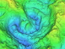
Radar Imaging of the Earth's SurfaceThe adjacent images show a comparison of the Mt. Everest region (border of Nepal and Tibet). The top image was taken through thick cloud cover with synthetic aperture radar on the space shuttle Endeavor; The bottom figure is an optical image of the same region taken from Endeavor (Ref). One can see many of the same features in the two photographs (the photographs were taken at different times of the year, so they have different snow covers).The curving and branching features are glaciers. The radar technique used is sensitive to characteristics of the glacier surfaces such as the ice roughness and water content. Thus the glaciers show a variety of colors in the radar image but are a rather featureless gray or white in the optical photograph. |
|
 |  |  |
| San Francisco Bay imaged in IR from space | Fossil crater imaged with representation of gravity and magnetic field data | GOES-8 IR satellite image of water vapor in Earth's atmosphere |
The left figure shows the San Francisco Bay area imaged from space in the infrared (IR).
The middle figure shows a composite of local gravity and magnetic field variation data to image a 112-mile wide relic meteor crater in Yucatan that presently lies below several hundred meters of sedimentary rock. This crater, called Chicxulub, is famous because it is the leading candidate for the site of the asteroid impact that is thought to have killed the dinosaurs 65 million years ago in the K-T extinction (Ref).
The right image shows a GOES-8 weather satellite image in the 6.7 micron IR channel that is sensitive to the distribution of water vapor in Earth's atmosphere (Ref). The imager on this satellite records radiation emitted by water vapor in the upper troposphere. Regions with high concentrations of water vapor are bright, while dark spots signal lower water vapor concentrations.
 |
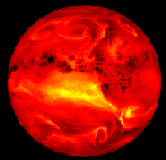
| Surface temperatures on Earth for January 30, 1997 |
Here is a link to the current temperature map (updated on a 6 hour cycle), and here is a movie (2MB MPEG---slow download) of the temperature varation over the past week.
 |
| Sea surface temperatures on Earth for January 29, 1997 |
Here is a link to the Current sea surface temperatures (updated daily).
