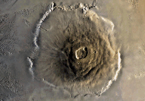
 Olympus Mons is 600 km across its base and about 25 km above the surrounding
plain. A perspective model is shown below
Olympus Mons is 600 km across its base and about 25 km above the surrounding
plain. A perspective model is shown below
Mars has many interesting geological features on its surface that first became apparent with Mariner 9, were subsequently studied by the Viking missions, and many of which now are visible from the Hubble Space Telescope.
Mars seems to be divided into two parts, the heavily cratered southern highlands, and the northern smooth lowlands. The cratered south is more than 3.5 billion years old, and the north was resurfaced 1 billion years ago. This is probably due to more volcanism in the north and some suggest the north was actually filled by a water ocean. Alternatively, maybe a large impact broke the crust in the north. The answer is not exactly known.
Olympus Mons is 600 km across its base and about 25 km above the surrounding
plain. A perspective model is shown below

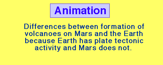 |
On the Earth, as crustal plates move over subsurface chambers of molten rock the lava tends to come to the surface in a line of places, producing strings of volcanoes (for example, volcanic island chains like the Hawaiian Islands). On Mars, with no horizontal motion of crustal plates the same point in the crust sits over subsurface chambers of molten rock and a few very large volcanoes are built rather than many small volcanos. Here is a more extensive discussion of volcanism on Mars.
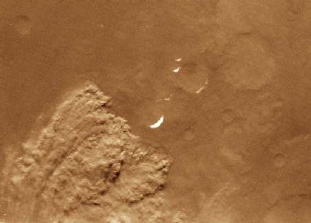
 The Martian surface has some large canyon systems. The largest is Valles
Marineris, which extends for about 5000 km, is 500 km wide in the widest
portions, and as much as 6km deep. The adjacent image shows a portion
of the Valles Marineris (the full system is shown in the preceding section).
This enormous system of connecting canyons appears to have been formed mostly
by local tectonic activity (local motion of surface) rather than by erosion,
though as we will discuss below there is some evidence for fluid erosion in
portions of it.
The Martian surface has some large canyon systems. The largest is Valles
Marineris, which extends for about 5000 km, is 500 km wide in the widest
portions, and as much as 6km deep. The adjacent image shows a portion
of the Valles Marineris (the full system is shown in the preceding section).
This enormous system of connecting canyons appears to have been formed mostly
by local tectonic activity (local motion of surface) rather than by erosion,
though as we will discuss below there is some evidence for fluid erosion in
portions of it.
The Valles Marineris faults are linked to a large volcanic bulge called Tharsis bulge. This has many smaller volcanos but Olympus Mons is just off of its northwest side. It is thought that a plume of rising magma underneath the crust has pushed up this bulge, and broken through in places to form volcanos and that the faults and the bulge exemplify that this is a thin region of the martian crust.
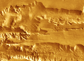
Running Water Erosion
There are channels on Mars as much as 1500 km long and 200 km
wide that appear to
have been cut by running water. Under present atmospheric conditions on Mars
(low pressure), water cannot exist as a free liquid on the surface (it must be
gas or solid). Thus, evidence for water erosion suggests that the Martian
atmosphere may have been more dense in the past. The following two images show
portions of the Martian surface where the erosion patterns have regions that
are very similar to those found for erosion by surface water on the Earth.
 |
 |
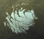
| Regions with possible evidence for water erosion on the Martian surface | |
 |
| A local dust storm on the Martian Surface (source) |
Here is another example of a Martian dust storm. At times, such local dust storms grow and merge until essentially the entire surface of the planet is covered by a dust storm. These periods are correlated with times of maximum solar heating of the Martian surface.
 |
 |
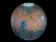
| The Martian polar caps (source) | |
These polar caps appear to be partially composed of frozen carbon dioxide ("dry ice") and partially composed of frozen water. A movie (775 kB) of the rotating Mars animation is also available.