The Surface Features of
Venus
 Our knowledge concerning the surface of Venus comes from a limited amount of
information obtained by the series of Russian Venera landers, and primarily
from extensive radar imaging of the planet. The radar imaging of the planet
has been performed both from Earth-based facilities and from space probes.
Our knowledge concerning the surface of Venus comes from a limited amount of
information obtained by the series of Russian Venera landers, and primarily
from extensive radar imaging of the planet. The radar imaging of the planet
has been performed both from Earth-based facilities and from space probes.
Photos showed mountains, craters, and plains and that most of the
rock is basalt which is typical of volcanism.
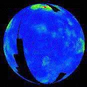
The most extensive radar imaging was obtained from the Magellan orbiter in a
4-year period in the
early 1990s. As a consequence, we now have a detailed radar picture of
the surface of Venus. The adjacent animation shows the topography of the
surface as determined using the Magellan synthetic aperture radar (black areas
are regions not examined by Magellan). An
MPEG movie (303 kB) of this animation is also
available. Magnellan could detect detail as small as 100m.
Overview of Surface
Altitude measurements are made by time delay radar imaging.
(measure how much time it takles for material to bounce back).
One can also measure the smoothness of the surface.
The smoother regions appear darker when radio waves
are impinged on such areas because they can fly off in
an arbitrary direction. For very rocky and rough surfaces,
the radio waves bounce around, and have less directions
that the waves can escape so they tend to come back in
the direction they came. (Think about watering a flat surface
with a powerful hose, the water sprays all over the place.
The water would be like the radio waves.) Thus smooth surfaces
tend to look darker than rough surfaces with the radar imaging technique.
65 percent of Venus is ROLLING PLAINS and the rest is highlands
and few percent mountains.
The rolling plains are smooth lava flows but with about 1000 craters.
The craters are spread uniformly over the surface (in contrast to our moon)
and look new. None are older than 500 million years. This suggests
that the older ones were washed out by lava flows in prior periods
of geological activity.
Also the craters are all large.
This is because the small meteorites are dissipated in the thick
atmosphere and do not reach the surface.
Volcanos are common on Venus and show up bright in radar images
but they are not found in chains as on the Earth.
Thus Volcanism is not the result of plate motion, sea spreading
or SUBDUCTION ZONES as on Earth but up-welling from hot-spots.
The peaks are shallow and called SHIELD VOLCANOS with very
fluid lava.
Volcanism usually occurs on Venus in circular CORONAE (not to be confused
with stellar coronae!!). These are 2000km bulges where molten
lava/magma has up-welled the surface and then retracted,
and allowed the surface to pull back. PANCAKE DOMES are evidence
for lava outflow in these regions. One usually sees a network of
concentric fractures in these regions.
There are lava channels on Venus, one is as long as the Nile river.
There are two "continents", which are large regions several kilometers above
the average elevation. These are called Ishtar Terra and Aphrodite
Terra. They can be seen in the preceding
animation as the large
green, yellow, and red regions indicating higher elevation
near the equator (Aphrodite Terra) and near the top pole (Ishtar
Terra).
Plate Tectonics on Venus? Not really but:
There appears to be evidence for
local tectonic activity but the surface appears to be a single crustal plate,
with little evidence for the large-scale horizontal motion of crustal plates
that we find on Earth.
That is, we see faults and wrinkled mountain ranges, but this
seems to be motion within a single pliable plate rather than interaction
between separate rigidly moving plates.
Why the two planets differ in this aspect of their geology
even though we believe them to have similar interiors is not well understood.
The usual explanation is that Venus is a little behind the Earth in geological
time scale, and its tectonic activity is just getting started.
It is thought that the crust is less dense on Venus than that on the
Earth and so this accounts for it being more pliable. It is also very hot
so it is not very stiff or rigid and is more bendable.
Earth loses 70 percent of
its heat through the rifts between plates,
venus gets rid of its heat through volcanos that rise from
within the crust and coronae regions of volcanic activity.
It is thought that rather than losing heat through motion
between plates as on Earth, venus loses heat by the periodic
sinking of parts of pliable crust, with lava overflowing
such regions. This is the OVERTURN model.
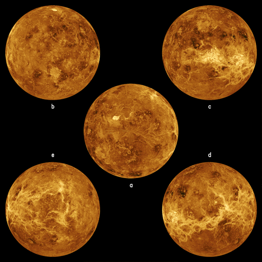
Hemispheric Views
The following images show 5 hemispheric views of the surface, again as
determined primarily from the Magellan mission.
 |
|
Hemispheres of Venus
(Ref)
|
The center image (a) is centered
at the North Pole. The other four images are centered
around the equator of Venus at (b) 0 degrees longitude, (c)
90 degrees east longitude, (d) 180 degrees and (d) 270
degrees east longitude. The simulated hues are based on color images
recorded by the Soviet Venera 13 and 14 spacecraft. (Here is a
more extensive discussion
of these hemispheric views.)
Examples of Surface Features
We now survey a few of the prominent types of surface features that have been
discovered on Venus.
Mountains
Venus has high mountains, many of which appear to be volcanic in origin.
The bright region near the center in
the polar hemispheric view (a) above
is Maxwell Montes,the highest mountain
range on Venus; it reaches an elevation of 11 km above average elevation (2 km
more than the elevation of Mount Everest above sea level on Earth).
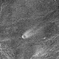
Volcanos and Lava Flows
There is strong evidence that
volcanoes have erupted on Venus in the
geologically recent past, and strong indirect evidence from observations
like changing
chemical composition of the atmosphere and the detection of lightning
in certain regions that volcanos are
presently active on Venus, though we do not yet have direct proof.
(Here is a
map of volcanic structures on Venus.) One piece
of evidence for recent volcanic activity is the presence in many regions of
features that look like relatively new lava flows. The two images shown
below
illustrates a volcano about 3 miles in diameter near Paragon Chasma (left)
and an image of apparent recent lava flows in the Sif Mons region.
In all of
these radar images you should bear in mind that bright spots correspond to
regions that reflect more radar waves than other regions. Thus, if you could
actually see these regions with your eyes the patterns of brightness and
darkness would probably not be the same as in these images. However, the basic
features would still be the same.
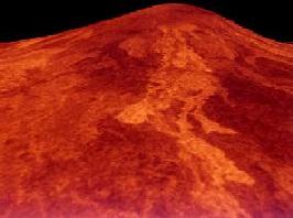
Rift Valleys: Different from those on the Earth
There are rift valleys as large as the East African Rift (the largest on
Earth). The image shown below illustrates a
rift valley
in the West
Eistla Region, near Gula Mons and Sif Mons. However
this is not believed to be the separation between
two rigid plates (as it would be on the Earth) but
rather a weakening and spreading within a single plate,
perhaps on its way to form two plates.
 |
|
Rift valley on Venus
|
The perspective in cases like this is
synthesized from radar data taken from different positions in orbit.
The East
African Rift on Earth is a consequence of tectonic motion between the African
and Eurasian plates (the Dead Sea in Israel is also a consequence of this same
plate motion). Large rift valleys on Venus appear to be more a consequence of more
local tectonic activity, since the surface of Venus still appears to be a
single plate.
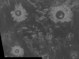
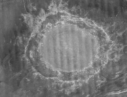
Meteor Craters
The surface of Venus has been smoothed by recent lava flows and by interaction
with the corrosive atmosphere. However, there are various examples of meteor
craters. The following images show a field of craters (left)
and the largest crater
found (right).
 |
 |
A Field of Craters
|
The Largest Crater
(Ref)
|
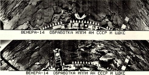
The View from Venera
Here are two of the images taken by the Russian Venera 14 lander. The
image is poor quality, but we can see in black and white the bottom of the
spacecraft, rocks on the surface, and a portion of the horizon.
 |
|
The surface of Venus from Venera 14
(Ref)
|
Summary of Venus' History
We can consider the usual planetary 4 stage planetary
history for venus:
1. Venus formed only slightly closer to the sun than Earth. Its density and
size tell us it should have dense interior but we are puzzled
by absence of magnetic field. (25,000 times weaker than that of Earth).
This also means that Venus is NOT protected from the solar
wind and the solar wind penetrates very close to
the planet developing a BOW SHOCK much nearer to Venus
than the similar effect produces on Earth and a denser
ION TAIL (see fig 23-12 of text) for Venus.
2. Cratering shows large craters and young cratering impacts compared
to our moon but old compared to Earth. This is based on frequency and structure
of impacts. Also there are no small craters.
3. There was lava flooding but no water flooding because the water
was dissociated by the hot surface temperature which evaporated
liquid water and then UV radiation from the Sun dissociated the water.
4. Slow surface evolution:
There is little surface erosion because of the absence of water,
but there is volcanic activity and lava flows.
The overturn model for crust motion
may explain how Venus
loses heat and could maintain a solid core, and avoid having a strong
magnetic field. (Solid core means no dynamo to sustain the field,
as discussed earlier.)